As we can see on the map of Mexico, the country lies south of the United States, with which it shares a border of about 3,145 kilometers. Its area covers nearly 1,964,375 square kilometers. Although its mineral resources are very diverse, the amount of arable land is limited. The country’s economic growth has been slowed by rapid population increase, which was estimated in 2015 at around 121 million inhabitants.
Table of contents
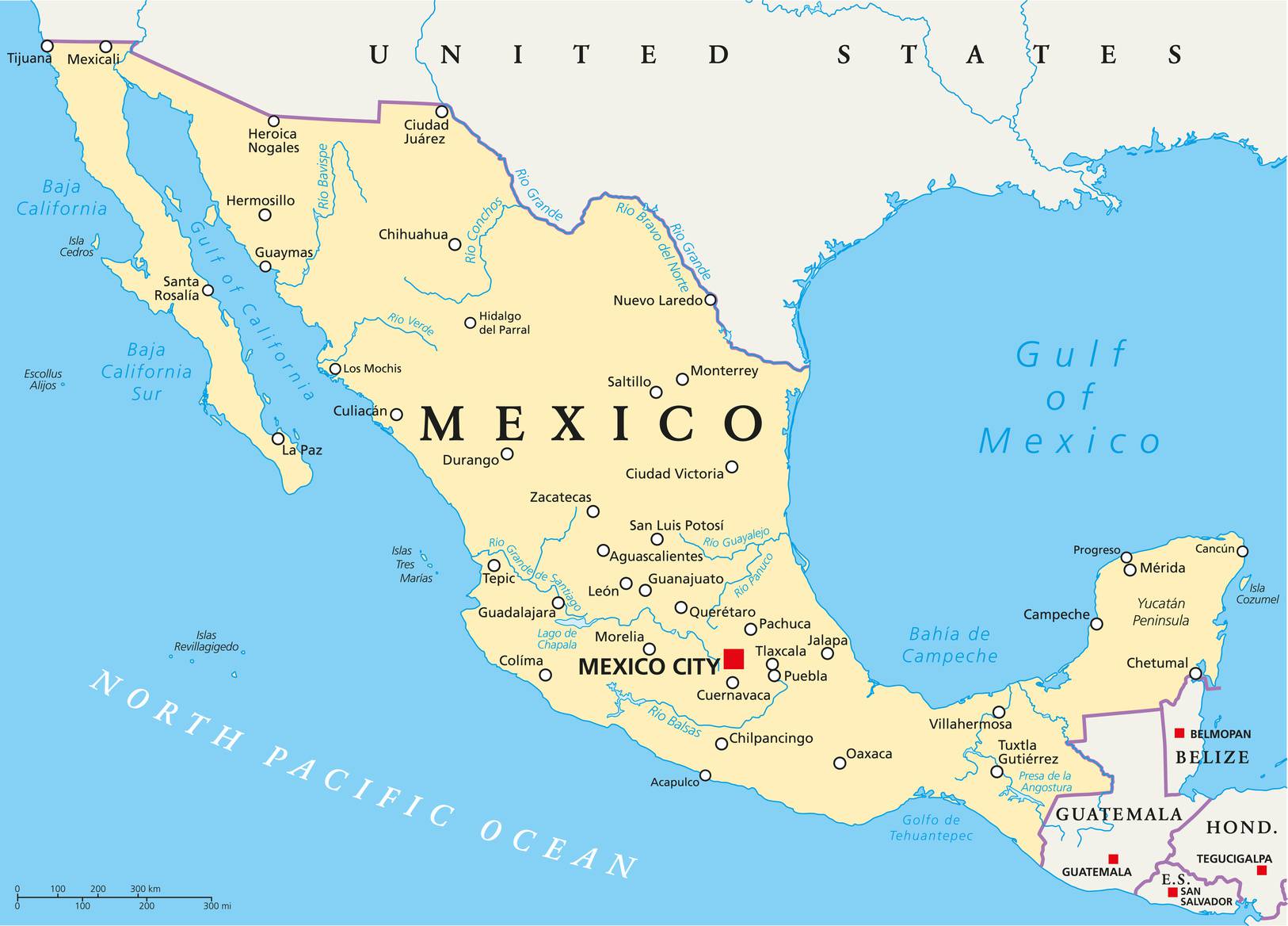
Simple map of Mexico – © Peter Hermes Furian author – stock.adobe.com
The average population density is therefore above 61 inhabitants per square kilometer. The population is concentrated mainly in the center of the country, but remains very sparse in the far north, which is very arid, and in the south, where a tropical climate prevails.
Evolution of the country
The commonplace image of Mexico as an essentially rural and agricultural country has today become completely obsolete. The economy now relies on oil production and tourism. The industrial sector is also expanding rapidly. Rural exodus has led to the fast development of urban areas, where nearly two-thirds of Mexicans currently live.
Mexico City (see the city’s location on the map of Mexico) is not only the capital of Mexico but also the country’s largest city and one of the largest metropolitan areas in the world. It is home to nearly 16 million inhabitants. While still relatively low by U.S. standards, gross national product per capita rose considerably during the 1970s. Despite significant socio-economic progress, Mexico has nevertheless had to face, since 1981, a rapid and worrying inflation rate, as well as external debt that increased after the unexpected fall in oil prices on the global market.

Map of Mexico’s regions – © pbardocz – stock.adobe.com
Geography with the map of Mexico
From a geological standpoint, Mexico is located in one of the most active regions on the planet. It is in fact part of the “Ring of Fire”, i.e., the zone characterized by intense volcanic activity that surrounds the Pacific Ocean. It is also situated on the western edge of the vast North American tectonic plate. Mexico therefore has very rugged terrain, and the territory is dotted with high peaks, often volcanic.
Pico de Orizaba, for example, rises above 5,500 meters (as can be seen on the map of Mexico) and only formed at the end of the Tertiary. The very spectacular and devastating eruption of El Chichón in 1981, by far, overshadowed that of Mount St. Helens, which had taken place the previous year in the United States.
The topography of southern Mexico is relatively complex and is explained by plate tectonics. The country is, in fact, affected by frequent earthquakes. In 1985, an earthquake whose epicenter was located at Acapulco caused billions of dollars’ worth of damage in Mexico City and led to the death of several thousand people.

Map of Mexico’s relief – Image extracted from maps-for-free
The regions of Mexico
It may not be obvious on the map of Mexico, but the country can be divided into eight major regions. The most important of them includes the Mexican Plateau, which begins at the Isthmus of Tehuantepec, north of the U.S. border. Altitude gradually rises from 1,200 meters in the north to 2,400 meters south of Mexico City (which can be found on the map of Mexico). The plateau’s surface is marked by an alternation of basins and mountain peaks.
The plateau itself can be divided into two large sub-regions. The “Mesa del Norte” stretches between the border and San Luis Potosí. The soil there is very arid, and the hydrographic network is limited to a few permanent watercourses. To the west, the Mesa gives way to the Sierra Madre Occidental, with volcanic relief, whose altitude fluctuates between 2,400 and 2,700 meters. The landscape is crisscrossed by a multitude of rivers. Oriented westward, they carve deep, narrow canyons here and there.

Blank map of Mexico – Credit Actualitix
The most spectacular is undoubtedly Barranca del Cobre, the Mexican equivalent of the Grand Canyon. The Sierra Madre Oriental, for its part, is marked by the presence of a mountain range made up mainly of limestone rocks. The altitude is generally similar to that of the Sierra Madre Occidental, but some peaks rise to more than 4,000 meters.
The Mesa Central stretches from San Luis Potosí to Mexico City. The surface of this plateau of volcanic origin is relatively less rugged and much more humid than that of the “Mesa del Norte”. Altitude is also higher. The Mesa Central is crossed by a whole series of basins framed by volcanic peaks marked by intense erosion.
These basins, generally very fertile, have for several years been the most densely populated regions of Mexico. But the surface area of the largest valleys, such as those of Mexico City, Puebla and Guadalajara, which can be found on the map of Mexico, does not exceed 260 square kilometers.

Mexico on a map of North and Central America – Credit Actualitix
The country’s largest cereal-growing region is located in the north of this mesa: in the Bajío region of Guanajuato. Most of these basins contain large lakes similar to those that once surrounded Mexico City before being drained to make settlement of the land easier.
The region is, however, subject to frequent earthquakes. This instability causes the collapse of many buildings. The main volcanic range runs along the southern edge of the Mexican Plateau and includes very high peaks whose summits are covered with snow for most of the year, such as Popocatépetl (5,452 meters), Iztaccíhuatl (5,286 meters) and Toluca (4,572 meters). You can see these reliefs on the map of Mexico.
The plains

Map of dangerous areas in Mexico – Credit: Ministry of Foreign Affairs
To the west and east, the plateau is fringed by vast coastal plains. The Gulf of Mexico coastal plain stretches from the Texas border to the Yucatán Peninsula over 1,450 kilometers. It is dotted with many lagoons and marshes. Inland, several plains interspersed with hills and low mountains follow one another up to the Sierra Madre Oriental.
Not far from Tampico, the Sierra Madre Occidental continues all the way to the coast. Here and there, the coastal plain gives way to isolated volcanic peaks that rise along the shoreline. It widens in the far north of the Isthmus of Tehuantepec and eventually includes the limestone formations of the Yucatán Peninsula.
The plains along the Pacific, on the other hand, are much narrower. They begin in the Mexicali valley in the north and stretch south for 1,450 kilometers, as far as Tuxpan.
They are bordered to the east by the Sierra Madre Occidental and form a succession of terraces, mesas and small basins interrupted by several deltas. From the 1940s onward, this region was partly irrigated to allow the expansion of cultivated land.
Relief
The Baja California Peninsula, found on the map of Mexico, lies immediately to the west of the Pacific plains. This relatively narrow peninsula stretches for 1,300 kilometers, but is no more than 160 kilometers wide. It is crossed by a major fault topped by peaks whose altitude exceeds 2,700 meters in the San Pedro Mártir region.
Very steep in the east, they are much less abrupt in the west, but nevertheless make access to the Gulf of California difficult. The very rugged terrain and extreme aridity of the soils have limited settlement in this part of Mexico. The coastline has, however, become one of the major hubs of Mexican tourism.
A little further south, the Mexican Plateau gives way to the Balsas Depression, whose name refers to the region’s largest river. This area, where irregular basins alternate with mountainous zones, has a particularly hot and dry climate.

Mexico on a world map – Credit Actualitix.com
Mountain areas
The mountain areas of southern Mexico contain steep massifs broken up by a whole series of plateaus. To the east, the Sierra Madre del Sur rises on a crystalline basement and stretches from Puerto Vallarta to the Gulf of Tehuantepec. Its altitude fluctuates between 2,100 and 2,400 meters. It extends to the coast, where it forms the famous “Mexican Riviera”.
The picturesque sites of Manzanillo, Ixtapa-Zihuatanejo, Acapulco and Puerto Escondido attract many tourists each year, while the basins located inland host agricultural operations that are generally not very profitable. To the east of the Sierra Madre del Sur, the altitude of the Mesa del Sur—crisscrossed by a multitude of rivers and isolated valleys—fluctuates between 1,200 and 1,500 meters. The highest population densities are recorded in the Oaxaca valley, where the population is largely made up of Indigenous peoples.
This region, one of the poorest in Mexico, is nevertheless famous for the beauty of its landscapes.
The Isthmus of Tehuantepec separates the south of the country from the Chiapas massif, which stretches over 200 kilometers and whose altitude is generally below 275 meters. The center of the country is framed by narrow coastal plains.
The Chiapas massif, in southeastern Mexico, lies in the extension of the Central American mountain system. The Sierra Madre de Chiapas, made up of crystalline rocks, runs along the Pacific coastline.
