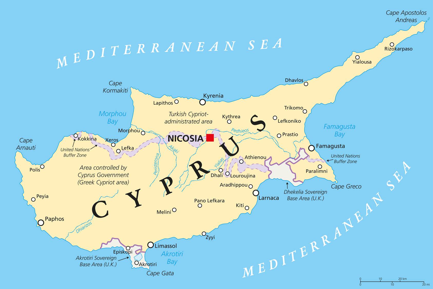
In this article you will find a map of Cyprus. This Mediterranean island state lies approximately 65 kilometers south of Turkey and 100 kilometers west of Syria.
With an area of 9,250 square kilometers, Cyprus is the third largest island in the Mediterranean. Since 1974, the northern part of the island has been under the control of Turkish Cypriots.
Map of Cyprus – © lesniewski – stock.adobe.com
Table of contents
Geography with the map of Cyprus
As shown on the map of Cyprus, the island can be divided into four main regions: the Kyrenia mountain range in the north; the Troodos mountain range in the south; the Mesaoria Plain in the center; and the coastal plains that stretch around the entire island. Cyprus’ highest peak, Mount Olympus, rises to 1,953 meters above sea level.

Map of the regions of Cyprus – © lesniewski – stock.adobe.com
It once contained numerous copper deposits, now depleted. This mineral even takes its name from the island, where it was the main mining resource since ancient times. The Mesaoria Plain is the island’s main agricultural center, but irrigation is essential for most farms. The Kyrenia range is famous for the beauty of its medieval castles, whose construction dates back to the time of the Crusades.

Cyprus map
Climate
With its location, as seen on the map of Cyprus, the island has a Mediterranean climate characterized by hot, dry summers and rainy winters. In Nicosia, the capital, daytime temperatures average 36°C and the sun shines for more than 11 hours a day during summer.
In winter, a few rare frosts are recorded in the mountainous regions of the Troodos. Annual rainfall averages no more than 48 centimeters and most rivers dry up completely for most of the year.
Population in Cyprus
Most Cypriots are of Greek origin (as seen on the map of Cyprus, given its proximity to Greece). They speak Greek, make up nearly 95% of the population, and are mostly members of the Orthodox Church. Part of the population, however, is of Turkish origin, with settlement on the island dating back to the Ottoman Empire. Turkish Cypriots speak Turkish and are generally Muslim.

Blank map of Cyprus
After the Turkish invasion in 1974, Greek Cypriots left the north of the island to settle in the south. Cyprus is largely rural and has only two cities with populations exceeding 100,000 inhabitants: Nicosia and Limassol (see the map of Cyprus). Greek and Turkish are the two official languages.

Cyprus on the world map
Economy of the island
After suffering from the impact of the Turkish invasion in 1974, the economy is now experiencing slow but steady growth. Agriculture employs the majority of the workforce. Potatoes, citrus fruits, grapes and barley are the leading crops.
Among the main manufactured products are food products, beverages, cement, bricks and tiles. The island of Cyprus also exports large quantities of clothing, shoes, cement, paper and cigarettes. The main mining resources are now asbestos and gypsum. Despite political instability, tourism remains one of the most dynamic sectors of the economy.
You can discover all the available maps for the different countries of the world on this page.
