Discover one (or several) map(s) of the USA (United States). The country embodies many ideals. For most of those who landed on its shores, this nation represented a true ideal of freedom — freedom to practice the religion of one’s choice, to work in a job suited to one’s abilities and personal interests, and finally, to be judged by an egalitarian legislative system.
")
Map of the USA (United States) – Credit Nations Online Project
Below, you will find direct links to the maps; given the large number of them, some may appear in sections that are not directly related to their content.
The nation also embodies, in the eyes of the world, the ideal of progress based on the idea that economic and social institutions, political life and citizens’ private lives can be improved through: hard work, honesty and loyalty.
This country is also guided by a democratic ideal based on the right to express one’s individual viewpoint, to participate freely in elections, to dream of a better life and to work according to one’s own goals.
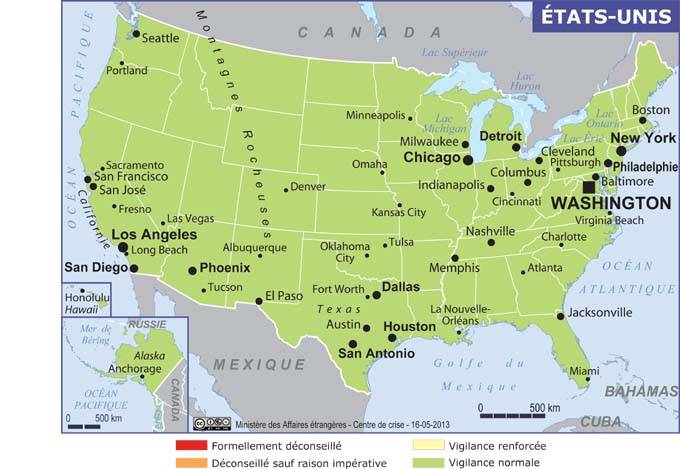
USA (United States) map – Credit: Ministry of Foreign Affairs
To understand a country as complex as the United States, it is important to take into consideration the role played throughout its history by the characteristics of its territory and by the pursuit of the ideals we have just mentioned.
The country is located between Mexico and Canada, as you can see on the map of the USA (United States). It lies to the north, between the Atlantic and Pacific Oceans. However, two of the 50 states that make it up are far from its continental core. Hawaii is in the Pacific Ocean, 3,900 kilometers from San Francisco.

United States map – Credit Nations Online
Alaska, in north-west North America, is located nearly 700 miles from Seattle, Washington.
As you can see on the map of the USA (United States), taking the most remote states into account, the total area amounts to 9.834 million square kilometers. The United States ranks among the world’s top countries (4th) in terms of land area and population. The latter was estimated at 320 million inhabitants according to the 2014 census data.
The American landscape has continued to evolve for millions of years. High mountains gradually saw their altitude reduced by erosion. Riverbeds changed course. Plains and plateaus followed one another across the territory. The relief is varied, as we will see later on the map of the USA (United States).

Relief map of the USA – Image extracted from maps-for-free
Glaciers created new landforms and moved fertile soils from one place to another. Irrigated lands became desert, lakes appeared in arid and uncultivated territories.
Article outline
Map of the USA (United States): regions and relief
The territory of the United States is dominated, on the one hand, by plateaus and an ancient mountain range—the Appalachians—stretching from north to south in the eastern part of the North American continent, and, on the other hand, by recent, high mountain chains—the Rockies, the Cascade Range and the Sierra Nevada—in the north and south of the western quarter of the continent.
The vast interior lands extend from the Canadian Shield to the Gulf of Mexico. These very characteristic areas of plains and mountains make it possible to define what are called the “physiographic” provinces of the United States. These contrasts are easy to see on the map of the USA (United States) (relief).
")
Map of the USA (United States) – Credit Nations Online Project
The Gulf of Mexico and Atlantic coastal plains
These plains stretch for 3,450 kilometers, from Cape Cod to the Rio Grande. Their western edge runs along the Piedmont located in the Appalachians. They then continue into the Mississippi River Valley, from Cairo (in the state of Illinois) to the Balcones Escarpment (in Texas).
The coastal region consists of a vast continental shelf characterized by low altitude and gentle relief. To the east, the shoreline features, in succession: the glacial deposits of Long Island, the estuaries of New York and Delaware, the bays of Chesapeake, Albemarle and Pamlico, not forgetting the sea islands off Georgia. From Cairo (in Illinois) to the Mississippi Gulf, the slope decreases steadily from 12.6 centimeters per kilometer, then to less than 9.5 centimeters per kilometer.

Relief map of Alaska – Image extracted from maps-for-free
Oxbow lakes formed from the many meanders of the river. South of New Orleans, the river created an immense delta that continues to expand.
The Appalachians
Immediately to the west of the Atlantic coastal plains rises the Piedmont, which you can see on the map of the USA (United States), followed in turn by the Blue Ridge Mountains, Ridge and Valley, and finally the Appalachian Plateau. All these regions belong to sub-provinces that depend on the highlands of the Appalachian system. New England and the Adirondack Mountains, located further south, are also part of it.
")
Blank map of the USA (United States) – Credit Actualitix
North of the Potomac River, the Piedmont overlooks the coastal plains at an altitude between 30 and 60 meters. Rivers flowing down its slopes form waterfalls when they reach lower elevations. The “fall line” is an imaginary line linking all these waterfalls together. Washington, D.C., Philadelphia and Baltimore lie on this line (see the map of the USA (United States)), as do the cities of Richmond, Raleigh, Columbia and Macon, further south.
From this “fall line”, altitudes increase steadily as you move westward, forming a succession of hills rising to an altitude between 335 and 365 meters near the Blue Ridge range. In the north, the Hudson Palisades opposite New York City and the Watchung Mountains are also considered part of the Piedmont. The same is true of Georgia’s Stone Mountain.

Another blank map of the USA – Credit Actualitix
The eastern escarpment of the Blue Ridge Mountains, or “cliff lines”, stretches from Pennsylvania to Georgia. It overlooks the Piedmont region at an altitude between 300 and 460 meters above sea level. In western North Carolina, many peaks rise above 1,800 meters (easy to recognize on the map of the USA (United States), the one showing relief). Mount Mitchell, the highest summit, stands at 6,684 feet above sea level. To the west, the ancient Blue Ridge massif meets the newer folded mountains of the Ridge and Valley Province.
The Ridge and Valley region extends from the St. Lawrence River (which you can find on the map of the USA (United States)) down to Alabama in the south. There is then a succession of valleys and linear ridges oriented north-east to south-west. The Great Valley region includes Lake Champlain, part of the Hudson River, as well as the valleys of Lebanon, Cumberland, Shenandoah, Tennessee and Coosa.
 on a map of North and Central America")
USA (United States) on a map of North and Central America – Credit Actualitix
In the Allegheny Front region, the Appalachian Plateau rises above Ridge and Valley at an altitude of 900 meters. Its surface, mountainous in places, has been deeply cut by several rivers. For example, the Kanawha River flows between 300 and 460 meters below the surface of the Appalachian Plateau. The highest altitudes of the plateau are located in the Catskill Mountains, and the most picturesque landscapes are found in the Finger Lakes region—both places belong to the state of New York, which is easy to identify on the map of the USA (United States).
New England and the Adirondacks were shaped by glaciation. Kettles, kames and moraines are common there. New England is famous for its rocky, jagged coastline. In some places, isolated mountains rise above the surrounding lands; these are called “monadnocks”, such as Mount Monadnock.
 on a map of the world")
USA (United States) on a map of the world – Credit Actualitix
The Central Plains
From the Appalachian range, they extend westward to the Great Plains, then from the Interior Highlands northward to the Canadian Shield. Their elevations range between: 300 meters in the far east; 150 meters along the Mississippi River; and up to 600 meters at the edge of the Great Plains.
Most of this geographical area was affected by glaciation. This led to the formation of the Great Lakes, which you can find on the map of the USA (United States), as well as a topography characterized by kames and kettles. Far to the north, the Red River Valley, famous for its spring wheat, is all that remains of glacial Lake Agassiz.
In places spared by glaciation, for example in the Wisconsin region, the relief is quite unusual. There are stone arches and natural bridges as well as, here and there, a few “monadnocks”. The plains, stretching east and west of the Mississippi, are covered by loess, a kind of wind-deposited silt long subjected to erosion.
The Interior Highlands
Unlike the Appalachians, their topography is oriented east to west. The linear ridges of the Ouachita Mountains rise to 2,600 feet (790 meters) and overlook the Arkansas River by 460 meters. The Boston Mountains stand at an altitude of 600 meters above the Arkansas and White rivers.
On the Ozark Plateau, the two peaks of Iron Mountain and Pilot Knob rise to more than 300 meters. Locally, the relief ranges between 240 and 270 meters. Broadly speaking, the topography is similar to that of the Appalachians.
The Lake Superior Uplands
They are part of the St. Lawrence Highlands or the Canadian Shield. They extend into north-eastern Minnesota, northern Wisconsin and the Upper Peninsula of Michigan. Glacial lakes are common. Iron ore deposits are also found at Cuyuna, Mesabi, Vermilion, Gogebic, Marquette and Menominee.
The Great Plains (Great Plains)
The Great Plains extend from Montana and North Dakota down to Texas—states you can find on the map of the USA (United States). To the north, the Missouri Coteau forms their eastern edge. In Texas, it is marked by the Balcones Escarpment. In Kansas and Nebraska, however, this boundary line is barely perceptible on the map of the USA (United States).
The altitude of the plains increases gradually as you move westward—from 600 meters along their eastern edge to almost 1,500 meters where they meet the Rocky Mountains.
The High Plains, located between Nebraska and Texas, are remarkably flat and little marked by erosion. In western Nebraska, there are dunes, while in western South Dakota are the Black Hills—a massif detached from the Rockies that rises 3,000 feet above the level of the plains.
The Rockies
The Rocky Mountains rise above the Great Plains to an altitude between 1,500 and 4,270 meters. Their jagged high peaks rise more than 14,000 feet above sea level. To the west, the Rockies overlook the Cordilleran Plateaus. The mountain ranges of the Colorado Front Range, Sangre de Cristo, Laramie, Wind River and Wasatch, as well as the Uinta, Bighorn and Bitterroot mountains, are part of the Rocky Mountain system. (See the map of the USA (United States) showing relief.)
The main passes are found at South Pass in the Wyoming Basin—one of the favorite routes taken by immigrants heading west.
The Cordilleran Plateaus
They are located west of the Rockies and consist of: the Colorado Plateau, the Great Basin, and the Columbia River and Snake River Plateau. The Colorado River carved the surface of the Colorado Plateau and thus ended up forming the Grand Canyon. In places it reaches a depth of 1,800 meters and a width ranging from 0.2 to 29 kilometers.
The whole plateau is characterized by jagged mesas, rounded summits, arches and natural bridges, stone monuments and rock spires. Monument Valley, located in north-western Arizona, is the best illustration. In New Mexico, Shiprock rises 430 meters above the surrounding lands.
The Great Basin region lies between the Rockies and the Sierra Nevada. It consists of many mountain ranges oriented north-south. These mountains rise to an altitude between 900 and 2,700 meters above the basin floor, or up to 3,000 meters above sea level.
In the past, most of the region was covered by Lake Bonneville. Today, the Great Salt Lake is all that remains. Lake Lahontan, for its part, covered western Nevada. Today, the Pyramid, Winnemucca, Honey, North Carson and Walker lakes are the only remnants.
Further north lies the Columbia River and Snake River Plateau, essentially made up of an immense lava flow. The Snake River carved a deep canyon into the lava, and the Columbia River (see the map of the USA (United States)) crosses the plateau’s surface. The two main topographic features are: the “Craters of the Moon” and the “Great Rift”.
The Pacific mountain system
This mountain system visible on the map of the USA (United States) includes: on the one hand, the Sierra Nevada and the Cascade Range to the east, and on the other, the coastal ranges along the Pacific to the west. Between them are: Puget Sound and the Willamette Valley in the north, and California’s Central Valley in the south. The Salton Sea and the Sonoran Desert are also part of it.
The Sierra Nevada stands at a much higher altitude than the surrounding regions. Twelve rocky summits rise to more than 14,000 feet above sea level. North of the Sierras lies the Cascade Range.
The gorge carved by the Columbia River divides it into two distinct parts: one to the south and the other to the north. In the southern Cascades, the two main topographic features are Crater Lake and Wizard Island. In the northern Cascades rise the following high volcanic peaks: Mount Rainier, Mount Adams, Mount St. Helens and Mount Baker.
The lowlands of the Puget Sound–Willamette Valley region extend between the northern Cascades and the Pacific Coast Ranges. California’s Central Valley, 640 kilometers long, lies between the Sierra Nevada and the coastal mountains. The latter also host the San Andreas Fault. Tectonic movements along this fault were responsible for the earthquakes that struck San Francisco hard in 1906 and in 1989.
A breach on the right bank of the Colorado River led to the formation of the Salton Sea in 1905. Water from the Colorado’s bed rushed into this gap and poured directly into the Salton basin. In 1907, the river level was measured. Since then, the Salton Sea has continued to shrink. Most of the Sonoran Desert lies north-west of Mexico City.
Alaska
The Pacific mountain system also extends into southern Alaska. The Alaska Range—in the Aleutian Islands province—forms a northern extension of the Pacific coastal mountain system. Alaska is a region you will find to the north-west on the map of the USA (United States).
The lowlands of Cook Inlet and the Copper River are a northern extension of the Puget Sound–Willamette Valley region. To the north rises an extension of the Cascades. Alaska’s interior lands are, for their part, an extension of the Cordilleran Plateaus. The Brooks Range is a northern extension of the Rockies.
As for the Arctic Coastal Plain, it finds its equivalent only in the Great Plains. However, the orientation of Alaska’s provinces is different: mountains and lowlands alike are oriented east to west. Mount McKinley, at an altitude of 6,194 meters, is the highest peak in all of North America. It is located in the Alaska Range.
The Hawaiian Islands
They consist mainly of volcanic mountain summits that mark the junction of two underwater mountain chains. The oldest islands are to the west, the most recent to the east. The volcanic mountain summits of the island of Hawaii rise well above sea level: Mauna Kea, at 4,205 meters, and Mauna Loa, at 4,169 meters.
These two volcanoes are still active. The summits on the islands of Oahu and Kauai are lower, as they have been shaped by erosion. The oldest islands are also surrounded by coral reefs.
The island of Oahu has a small coastal plain as well as an important harbor: Pearl Harbor.
Map of the USA (United States): climates
The United States is mainly affected by air masses blowing toward the south, the north and the east, and finally toward the west. These air masses come respectively from: Canada, the Atlantic Ocean and the Gulf of Mexico, and finally the Pacific Ocean. During winter, bursts of cold winds from the Arctic sweep across the north of the country.
At the end of summer, hurricanes from the Caribbean hit the Atlantic and Gulf of Mexico coasts hard. They sometimes even strike regions located further north. Throughout the year, westerly winds influence the climate and weather of most of the United States.
Westerly winds, laden with water vapor from the Pacific Ocean, blow over the Cascade Range and bring heavy precipitation on its western slopes, the most exposed to the wind. The eastern slopes, sheltered from the wind, therefore receive much less precipitation. The city of Portland, Oregon, and the Dalles region in California record average annual precipitation of 100 centimeters and only 33 centimeters respectively.
The Sierra Nevada mountains explain the relative dryness of the Great Basin. Average precipitation: 122 centimeters at Nevada City, California, and only 23 centimeters at Carson City, Nevada. The Great Plains lie in what has been nicknamed the “rain shadow” of the Rockies. As a result, Coeur d’Alene, Idaho records 56 centimeters of rain per year, while Great Falls, Montana receives only 38 centimeters per year.
In general, the 100th meridian separates the humid East from the much drier West. Annual precipitation exceeds 152 centimeters in New Orleans; 140 centimeters in Miami; 127 centimeters in Birmingham, Alabama; 102 centimeters in Boston, New York and Washington, D.C.; 76 centimeters in Chicago and St. Louis; but only 41 centimeters in Bismarck, N.D.; 71 centimeters in Wichita, Kansas; and 20 centimeters in Albuquerque, New Mexico.
Precipitation is, however, higher in the far north-west of the country. The city of Seattle records average annual precipitation of more than 90 centimeters.
In Alaska and the Hawaiian Islands, rainfall varies considerably. For example, annual precipitation reaches: 221 centimeters at Sitka; 43 centimeters at Nome; and less than 13 centimeters at Barrow.
Downtown Honolulu records annual rainfall of only 51 centimeters, while it rises to more than 508 centimeters in the surrounding hills. At Waialeale on the island of Kauai, average precipitation exceeds 1,219 centimeters, making it one of the wettest regions on the planet.
Temperature variations are also significant. The average January temperature is 20°C (68°F) in Miami; 13°C (68°F) in New Orleans; 0.6°C (33°F) in New York; -3°C (27°F) in Chicago; 11°C (52°F) in Phoenix; -0.6°C (31°F) in Denver; and 5°C (40°F) in Seattle. The average July temperature is: 28°C (82°F) in Miami; 28°C (83°F) in New Orleans; 25°C (77°F) in New York; 24°C (75°F) in Chicago; 32°C (91°F) in Phoenix; 23°C (73°F) in Denver; and 18°C (65°F) in Seattle.
In Fairbanks, Alaska, average January temperatures are -24°C (-11°F). In Honolulu, average January and July temperatures are 22°C (72°F) and 26°C (79°F). They are moderated by the influence of the Pacific Ocean.
The different temperature and precipitation regimes make it possible to divide the United States into nine distinct climatic zones. Four of them lie east of the 100th meridian, and the other five are west of it.
East of the 100th meridian are: tropical (savanna) climate, humid subtropical climate, humid continental climate with hot summers, and humid continental climate with cool summers. West of the 100th meridian are: steppe, desert, western highlands, Mediterranean regions, and maritime regions of the western seaboard. Alaska includes subarctic regions and tundra, which you can see on the map of the USA (United States). The Hawaiian Islands, for their part, belong to the oceanic region.
Tropical (savanna) climate
South Florida is characterized by tropical savanna. The climate, dry and wet, includes a well-defined dry season that occurs in winter. Miami’s rainfall amounts to 140 centimeters (55 inches). However, most of the rain falls in summer and spring due to the influence hurricanes have on this region. Nine of these 55 inches are recorded in October. Winter, which lasts half the year, is relatively dry. Temperatures remain uniformly high.
Humid subtropical climate
Humid subtropical climate is a warm, temperate and rainy climate with no dry season. This climate affects the region that includes: the Atlantic plains and the Gulf of Mexico coastline, most of the Appalachian system, and the interior highlands. The edge of this climatic zone approximately follows the 100th meridian. The 102 centimeters of rain recorded in Washington, D.C. are evenly distributed throughout the year. This is also the case in Charleston and New Orleans, whose rainfall totals 124 and 152 centimeters respectively. There is no dry season. Temperatures vary greatly between the southern and northern parts of the zone.
Humid continental climate with hot summers
This humid continental climate with hot summers lies north of the previous climate zone. Its northern boundary stretches just south of Lakes Erie and Michigan, while also including the region between western Pennsylvania and Kansas, Nebraska and South Dakota west of the 100th meridian.
The climate is cold, although summers are hot and winters are wet. In Pittsburgh, average precipitation reaches 89 centimeters and is evenly spread throughout the year. Average temperatures in January and July are respectively -0.6°C (31°F) and 23°C (74°F). In Omaha, Nebraska, average precipitation totals 71 centimeters. The average January temperature is 22°F (-6°C), but July rises to 25°C (77°F).
Humid continental climate with cool summers
It lies north of the previous climate zone. It affects: northern New England, the Great Lakes region, as well as parts of Minnesota and North Dakota west of the 100th meridian. This region is characterized by a cold climate where summers are cool and winters are wet. Average annual precipitation reaches 81 centimeters in Marquette.
Snowfall during winter makes up the largest share of this precipitation. The average January temperature is -9°C (16°F) and the average July temperature reaches only 18°C (65°F). The city of Duluth, Minnesota records annual precipitation of 66 centimeters with heavy snowfall. The average January temperature is -17°C (1°F), while the average July temperature—similar to Marquette’s—is 18°C.
Steppe
This is a mid-latitude region with a cold and dry climate characterized by winter drought. This region includes the Great Plains (see the map of the USA (United States)), most of the Great Basin, and parts of the Columbia and Snake River Plateau. The city of Helena, Montana receives less than 36 centimeters of rain per year. Nine of these 23 centimeters are recorded between April and September.
Winter is very dry. In Helena, average January and July temperatures are respectively -7°C (20°F) and 23°C (74°F). Boise, Idaho’s annual precipitation reaches only 30 centimeters. However, most precipitation falls there in winter due to the strong influence of proximity to the Pacific Ocean. In Boise, average January and July temperatures are respectively -17°C (29°F) and 23°C (74°F).
Desert
It includes: part of the Great Basin, the Salton Sea region, southern Arizona and New Mexico, as well as the Sonoran Desert. Precipitation is scarce and temperatures are high. In Yuma, Arizona, annual precipitation is less than 10 centimeters, and most of it falls during winter. From April to July, the climate is very dry. In Yuma, average January and July temperatures are 12°C (53°F) and 33°C (91°F). This region is visible on the map of the USA (United States).
Western highlands
They include the northern Rockies, the Sierra Nevada and the Cascade Range. This region, like the humid continental climate with cool summers, is characterized by cool summers and wet winters.
Mediterranean regions
In classic Mediterranean climate, the wettest winter month records three times more precipitation than the driest summer month. In most of western California, the climate is very close to this definition. San Francisco records annual precipitation of 54 centimeters, and winter alone accounts for 46 centimeters. No precipitation occurs during July.
