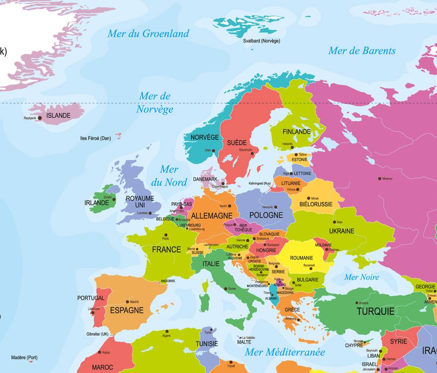
Discovering a map of Europe means exploring a continent that is both compact and remarkably diverse. Europe, one of the smallest continents on Earth, brings together nearly 40 sovereign states, along with several monarchies, principalities, and microstates. Traditionally, it also includes the most populated regions of western Russia and the “European” part of Turkey.
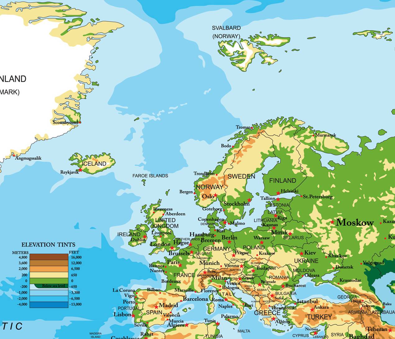
As the cradle of democracy, major artistic movements, and countless innovations, Europe enjoys worldwide recognition. Below is a map of Europe to help you locate its main areas.
Table of contents
- Map of Europe: geography and natural environment
- Countries, regions, and key administrative divisions
- Relief, mountain ranges, and landscapes
- Rivers, seas, and coastlines
- Climate in Europe: when to go?
- Population and languages
- Must-see tourist sites
- Transport and communication networks
Map of Europe: geography and natural environment
Europe lies on the western peninsula of the vast Eurasian landmass. Its “natural” borders are often described through a series of landmarks: the Ural Mountains, the Caspian Sea, the Caucasus Mountains, the Black Sea, and then the straits and seas that connect to the Mediterranean (the Bosphorus, the Sea of Marmara, and the Dardanelles). To the southwest, the maritime boundary extends as far as the Strait of Gibraltar.
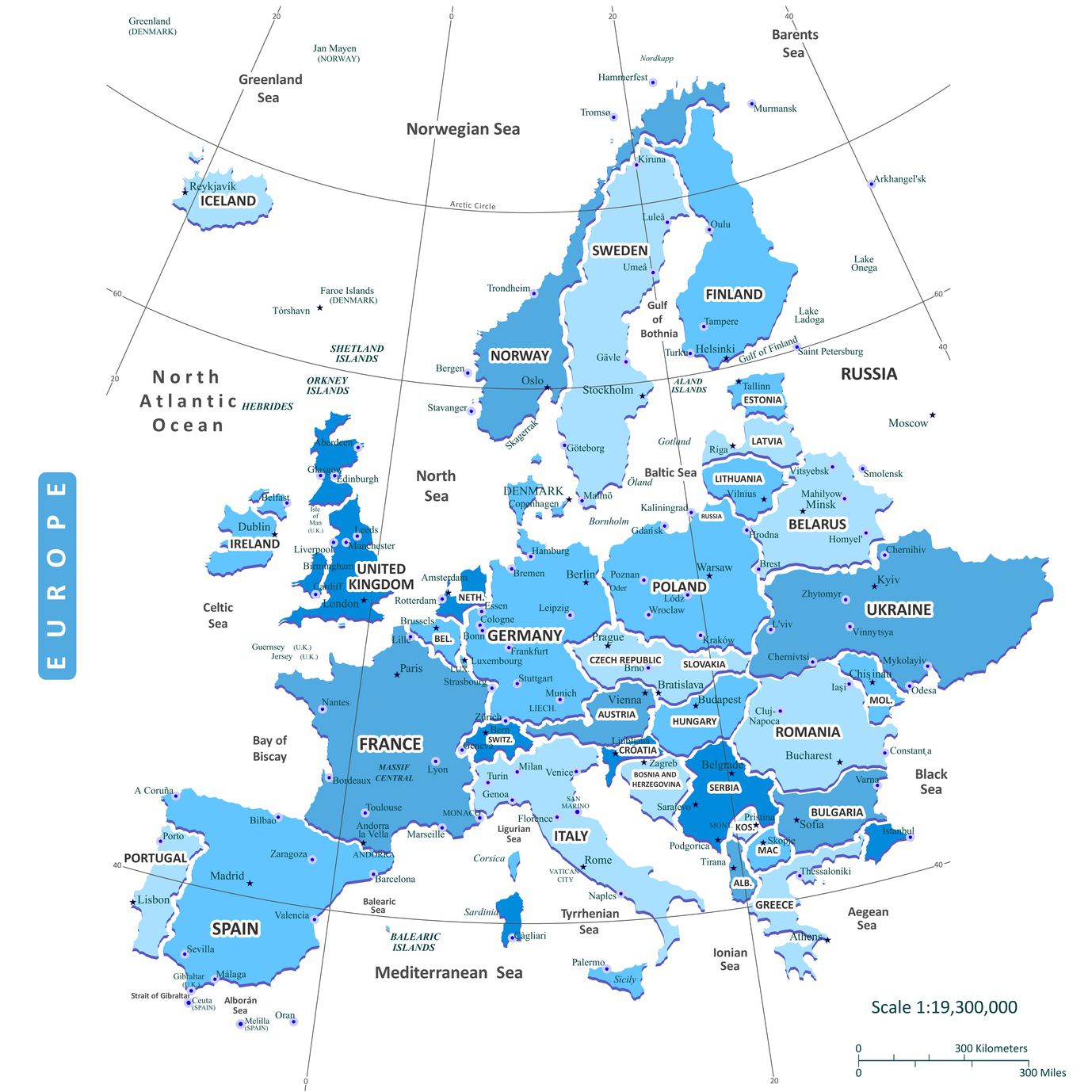
Countries, regions, and key administrative divisions
Countries in Europe
With an area of over 10 million km² (about 7% of Earth’s land surface), Europe stretches roughly between 35° and 81° north latitude. It forms a mosaic of countries of very different sizes: from large states (France, Germany, Spain, Ukraine) to microstates (Monaco, San Marino, the Vatican, Andorra, Liechtenstein).
Major European regions
On a map of Europe, it is common to distinguish four broad regions—useful for understanding differences in relief, climate, and population:
- Western Europe (France, Germany, Benelux, the United Kingdom, Switzerland, Austria, etc.): highly urbanized and strongly connected.
- Northern Europe (the Nordic countries): vast spaces, marked relief, low densities outside major cities.
- Southern / Mediterranean Europe (Iberia, Italy, the Balkans, Greece): drier summers and strong tourist appeal.
- Eastern Europe: large plains, varied landscapes, and colder winters inland.
Note (internal divisions): each country has its own administrative structure (regions, provinces, cantons, departments, municipalities, etc.). In France, for example, the hierarchy is regions → departments → communes (cities/towns), which can be helpful when reading detailed maps.
Relief, mountain ranges, and landscapes
Europe’s geological history is complex: it combines very old massifs in the north with younger mountain ranges in the south. East of the Carpathians and the Vistula lies a vast, relatively stable platform. Moving westward, landscapes shift between mountains, plateaus, plains, and hills.
The main “young” ranges with rugged relief include the Caucasus, the Pyrenees, and the Alps, all easy to spot on a map of Europe:
- Mount Elbrus (Caucasus): 5,633 m
- Aneto (Pyrenees): 3,404 m
- Mont Blanc (Alps): 4,807 m
In the north, the relief of Norway, Sweden, and Finland is older. The Kölen Mountains form a natural border between Sweden and Norway and cover much of Norway. Peaks often rise between 1,800 and 2,400 m, with Glittertinden reaching 2,470 m.
The Alpine ranges formed as the African and Eurasian plates converged, which explains their steep, dramatic relief. The Alps are crossed by many passes and tunnels, while access through the Caucasus and the Pyrenees is generally more challenging. Part of southern Europe (Italy, the Balkans, Greece, European Turkey) sits in a more unstable zone: earthquakes are more frequent, and volcanoes such as Vesuvius and Etna remain active.
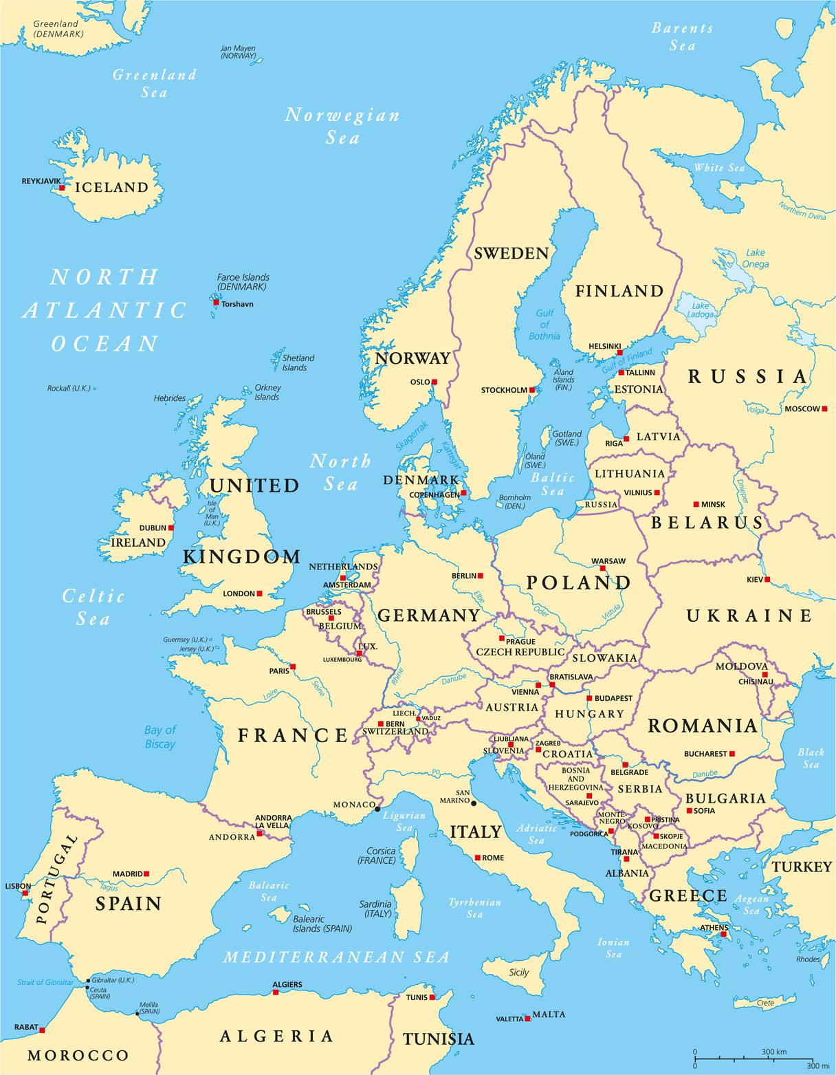
Rivers, seas, and coastlines
Europe has an extensive coastline, running along Scandinavia, the Iberian Peninsula, Italy, and the Balkans. Major islands and island territories include Crete, Sardinia, Corsica, Sicily, Ireland, Great Britain, Iceland, and the Svalbard archipelago.
Multiple seas (the Mediterranean, the Black Sea, the Barents Sea, and more) support dense shipping routes. In Western Europe, no country is very far from the sea, which has long encouraged trade and mobility.
As for hydrography, many major rivers in Central and Western Europe rise in the Alps. Key rivers include:
- Baltic Sea: Vistula, Oder
- North Sea: Elbe, Rhine
- France: Seine, Loire, Garonne (westward), Rhône and Saône (southward)
- Italy: Po
- Iberian Peninsula: Tagus, Ebro, Guadalquivir
- British Isles: Thames, Shannon
- Eastern Europe: Danube, Don, Volga, Dnieper, Ural
Climate in Europe: when to go?
Europe’s generally mild climate is largely shaped by surrounding seas and oceans, along with prevailing westerly winds that often bring humidity and moderate temperatures. Weather can change quickly as high- and low-pressure systems pass through, sometimes causing noticeable temperature swings.
From west to east, rainfall tends to decrease and temperature contrasts become stronger. In summer, the Azores High often limits rainfall in Mediterranean regions, while winter brings more low-pressure systems, cooler air, and heavier precipitation.
Main climate types
- Oceanic (Western Europe): mild winters, rarely extreme summers, rainfall spread across the year.
- Continental (Eastern Europe): warm summers, colder and longer winters, strong temperature ranges.
- Mediterranean (South): hot, dry summers; mild, wetter winters.
- Mountain climate: conditions vary with altitude and exposure; colder temperatures and more frequent snow.
Best time to visit (simple guidelines)
- Western European cities: spring (April–June) and early autumn (September) to avoid peak crowds.
- Mediterranean destinations: May–June and September–October for warmth without intense heat waves.
- Northern Europe: summer (June–August) for longer days and more comfortable temperatures.
- Mountains (Alps, Pyrenees, Carpathians): winter for snow sports; summer for hiking and alpine lakes.
In mountainous areas, climate changes sharply with altitude and slope exposure: the highest Alpine peaks keep glaciers and long-lasting snowfields.
Population and languages
Europe had roughly 740 million inhabitants in 2015, representing just over 10% of the world’s population. Population density varies greatly: it is high in major urban regions (London, Paris, the Ruhr, the Po Valley, etc.) and lower in northern, mountainous, or strongly continental areas.
Languages
Most European languages belong to the Indo-European and Uralic families. Romance, Germanic, and Slavic groups dominate, alongside Greek, Albanian, Baltic languages, and Celtic languages. Multilingualism is common, and English, French, German, and Spanish are among the most widely taught languages.
Must-see tourist sites
Europe attracts visitors from around the world thanks to its diverse landscapes and outstanding cultural heritage. Major destinations include:
- Paris: museums, landmarks, and lifestyle.
- Rome: ancient history, the Vatican, and architecture.
- London: museums, historic districts, and cultural life.
- Athens: ancient sites and Greek heritage.
- Vienna: classical music, palaces, and museums.
- Amsterdam: canals, museums, and a unique atmosphere.
- Barcelona / Madrid: architecture, gastronomy, and vibrant city life.
- Prague / Budapest: historic centers, Danube views, and thermal baths (Budapest).
Tourism plays a major role in many European economies, though it can also increase pressure on certain sites (overcrowding, pollution, and intensive development).
Transport and communication networks
Infrastructure density is particularly high in Europe, especially in the west, where road and rail networks are highly developed. Navigable waterways—especially around the Rhine—have long been crucial for trade, even if part of the flow has shifted toward rail, road transport, pipelines, and gas lines.
Europe’s railway network accounts for a significant share of global rail mileage, and high-speed trains have reduced travel times on major routes. Europe is also a major air transport hub, especially in densely populated countries with dynamic economies.
![]() Albania
Albania![]() Andorra
Andorra![]() Germany
Germany![]() England
England![]() Austria
Austria![]() Belgium
Belgium![]() Belarus
Belarus![]() Bosnia and Herzegovina
Bosnia and Herzegovina![]() Bulgaria
Bulgaria![]() Croatia
Croatia![]() Denmark
Denmark![]() Scotland
Scotland![]() Spain
Spain![]() Estonia
Estonia![]() Finland
Finland
![]() France
France![]() Greece
Greece![]() Hungary
Hungary![]() Ireland
Ireland![]() Northern Ireland
Northern Ireland![]() Iceland
Iceland![]() Italy
Italy![]() Kosovo
Kosovo![]() Latvia
Latvia![]() Lithuania
Lithuania![]() Luxembourg
Luxembourg![]() Macedonia
Macedonia![]() Moldova
Moldova![]() Montenegro
Montenegro![]() Norway
Norway
![]() Netherlands
Netherlands![]() Poland
Poland![]() Portugal
Portugal![]() Czech Republic
Czech Republic![]() Romania
Romania![]() Russia
Russia![]() Serbia
Serbia![]() Slovakia
Slovakia![]() Slovenia
Slovenia![]() Sweden
Sweden![]() Switzerland
Switzerland![]() Ukraine
Ukraine![]() Vatican
Vatican
