Discover a map of Azerbaijan. Located east of the Caucasus, Azerbaijan is one of the 15 republics of the former Soviet Union. The country is bordered by Russia and Georgia to the north, the Caspian Sea to the east, Armenia to the west, and Iran to the south.
Table of contents
Geography and climate with the map of Azerbaijan
The area of Azerbaijan is 86,600 square kilometers (approximately the size of Portugal).
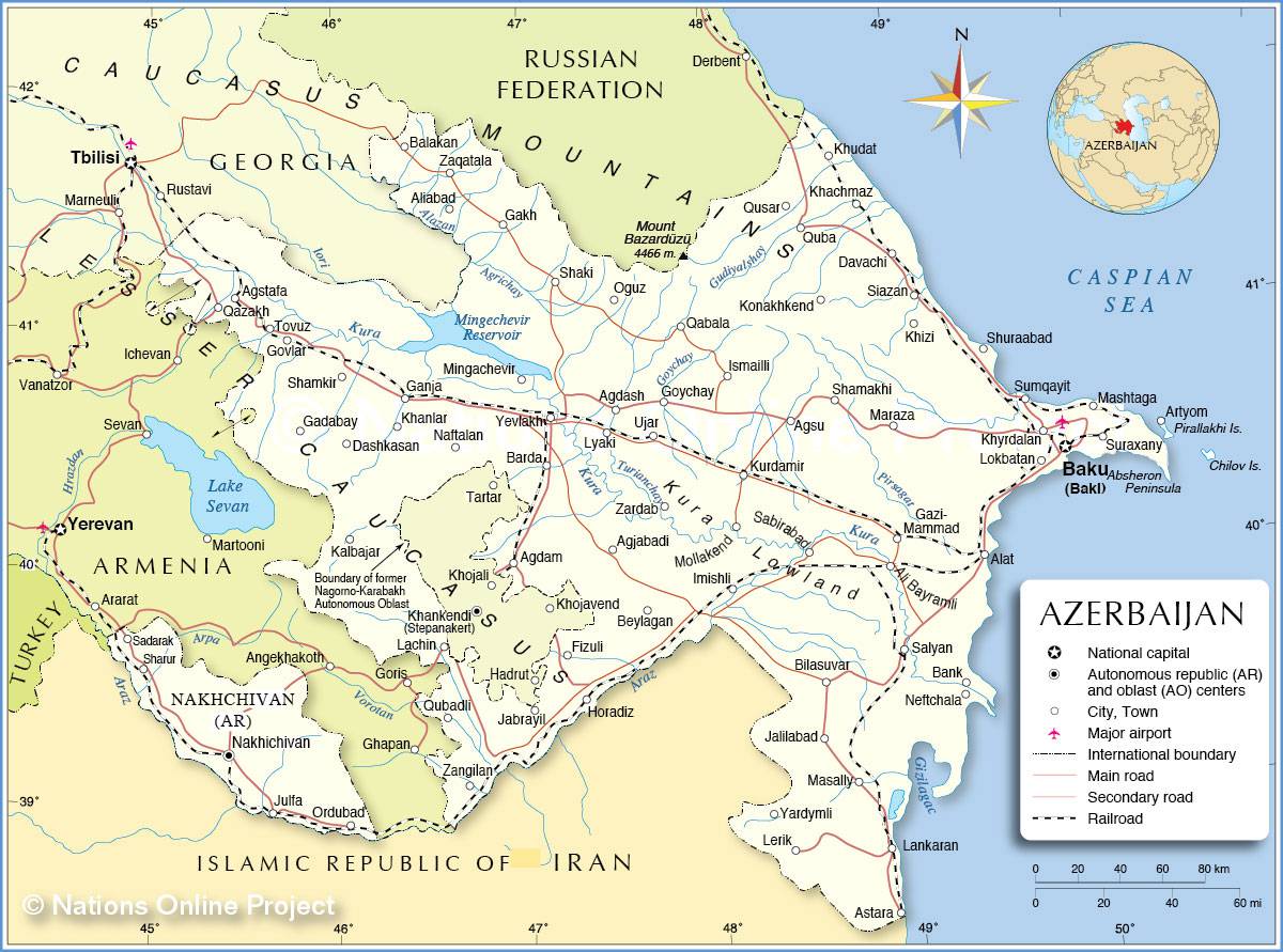
The south and north are mountainous; Mount Bazardüzü (4,480 meters) is the highest peak in the country. The central region is a vast plain crossed by the Kura River, as shown on the map of Azerbaijan.
The climate is dry and subtropical, with hot summers and mild winters. Rainfall is scarce in the plains. The mountains and the narrow coastal plain of Lankaran in the southeast receive more precipitation. In the plains and on the foothills of the Greater Caucasus, vegetation is steppe-like, with shrubs and dry grasses. At higher elevations, forests and pastures replace the steppe.
Population
Azerbaijanis have traditionally been farmers or shepherds, but more than half of the population now lives in urban areas. The development of the oil industry has attracted many Azerbaijanis to Baku, the country’s capital. The population of over 9.5 million people is composed mainly of Azerbaijani Turks. They speak Azeri, a Turkic language, and are predominantly Shia Muslims. Azerbaijan also controls Nakhchivan, an exclave separated from the rest of the country and populated by Azerbaijanis. Several million Azerbaijanis also live in Iran. The map of Azerbaijan below notably shows the country’s main cities.
In the Nagorno-Karabakh region, located in the southwest of Azerbaijan, Armenians have historically represented a large share of the population. Since 1988, tensions have existed between Azerbaijanis and Armenians following Armenian demands to attach Nagorno-Karabakh to the Republic of Armenia.

Economy
In the humid plains of Lankaran, farmers grow cotton, tobacco, wheat, barley, and maize, and also harvest potatoes, fruits, grapes, vegetables, citrus fruits, and tea. Irrigation makes rice cultivation possible. Livestock farming (cattle, sheep, goats), practiced both in the plains and in mountain pastures, provides meat and wool. Azerbaijan is also a major silk producer.
Numerous oil and natural gas fields are located in the Baku region. Most industries—refineries, steel plants, chemical and petrochemical factories—are concentrated in the Baku-Sumgait area. An oil pipeline runs from Baku to Batumi in Georgia, and gas pipelines transport natural gas to neighboring countries.
